Expert discusses deadly flooding along California coast due to torrential rain
Major parts of the West Coast, including large metro areas such as San Francisco, Sacramento, and Los Angeles are experiencing floods due to torrential rains and ‘atmospheric rivers.’ Waters are rising. But land is also subsiding, creating a major long-term hazard. Geophysicist Manoochehr Shirzaei weighs in.
Manoochehr Shirzaei, an associate professor of geosciences at Virginia Tech, wears a button down dress shirt outside Derring Hall. Photo by Steven Mackay.

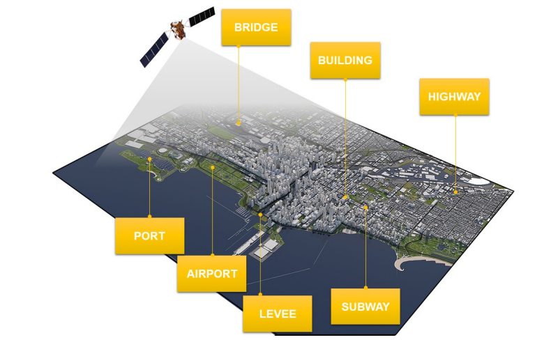
Violent storms continue to rake large portions of the California coast, causing heavy rainfall, mass flooding, wind damage, and up to 12 deaths. The storms started as a “bomb cyclone” over New Year’s weekend and seem to have not leveled off. On Sunday, President Joe Biden declared a federal emergency in California. Virginia Tech geophysicist Manoochehr Shirzaei has been closely tracking the storm system via satellite radar imagery. His main concern: outdated levees.
Quoting Shirzaei
“The main concern is the outdated levees, many of which were built decades ago -- without modern engineering -- to provide limited flood protection for fertile lands within the floodplain,” said Shirzaei, director of the Earth Observation Lab at Virginia Tech. “In recent years, on one hand, [there has been] increased population density and assets value, and on the other hand, [we have] rising sea levels and more frequent flooding and intense flooding due to climate change and, land subsidence exacerbates the hazards and risks associated with floods.”
Shirzaei’s lab has been in communication with various agencies and research centers in California to provide geospatial data obtained from radar satellites to assist in decision-making and assessing hazards and risks. The lab can perform “near-real-time monitoring with a few days’ latencies.” In order to complete real-time monitoring of such storms, Shirzaei said additional CubeSats would have to launched.
“Assuming that relocation is not viable, as sea levels rise and lands continue to subside, coastal flooding and erosion will likely become the single major hazard to coastal communities and the environment. Additionally, the current coastward migration of the population will likely increase the risk of flooding,” Shizaei said. “However, implementing defense mechanisms such as building new levees, upgrading existing ones, and enhancing/maintaining natural protection systems -– such as wetlands and mangroves -- can significantly reduce the risk of flooding to coastal communities.”
“California has been dealing with other end-member extremes, namely unprecedented droughts. In the era of climate change, such extreme events are becoming a norm” Shirzaei said. “Successful adaptation and mitigation strategies should take both extremes into account and harness the power of one to reduce the impact of the other. For instance, the excess water supply during atmospheric rivers can be treated and banked underground to be used during droughts.”
About Shirzaei
Manoochehr Shirzaei is an associate professor and geophysicist in the Department of Geosciences, part of the Virginia Tech College of Science. Director of the Earth Observation Lab at Virginia Tech, Shirzaei’s research recently has focused on promoting environmental security through quantifying the impact of the human system and climate change on the availability of water and energy resources in the U.S. He is an affiliated member of the Virginia Tech Global Change Center.
Schedule an interview
To secure a live or recorded interview, contact Shannon Andrea at sandrea@vt.edu or 703-399-9494 or Steven Mackay at smackay@vt.edu or 540-739-9434.