NASA explorer mission GOLD launches
Two new NASA missions are teaming up to explore the boundary between Earth and space.
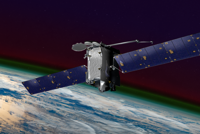
Set to launch Jan. 25 from French Guiana, the GOLD mission will be the first NASA science mission to fly as a hosted payload on a commercial communications satellite. The mission will provide unprecedented imaging of the Earth’s upper atmosphere from geostationary orbit.
Working in concert with a second satellite called ICON that will launch later this year, the missions will collectively provide the most comprehensive imaging of the upper atmosphere ever seen.
Scott England, associate professor in the Kevin T. Crofton Department of Aerospace and Ocean Engineering, is working on both explorer-class missions as the project scientist for ICON and co-investigator on the GOLD mission.
“Much of my group’s research will focus on analyzing the data from this mission, trying to use it to understand Earth’s upper atmosphere and how it changes over time,” said England, also a faculty member at Space@VT. “Radars, like the SuperDARN radar we operate, are able to see motion in the upper atmosphere over North America, which we can combine with GOLD’s observations of the composition and temperature of that region to perform some really unique studies that couldn’t be done with either one alone.”
GOLD, otherwise known as Global-scale Observations of the Limb and Disk, will launch on an Arianespace Ariane 5 ECA rocket as a hosted payload on the SES-14 commercial communications satellite. After reaching geostationary orbit, GOLD will begin its two-year mission.
The mission will be the first to study the conditions in the upper atmosphere across an entire hemisphere, rather than making measurements of a small region at a time. The GOLD mission will strive to make breakthrough measurements of temperature and composition of this region, important for satellite drag and disruptions of communication and navigation.
Starting 60 miles above Earth’s surface is the upper atmosphere, where the highest level of our atmosphere meets space. This region is in constant flux with the push-and-pull from Earth’s weather conditions much nearer the surface and changes in the space environment. By studying how the co-mingled weather in this layer interacts, researchers will better understand the conditions that affect radio signals used to guide airplanes and ships and satellites that provide our communications and support GPS systems.
Both GOLD and ICON have targeted, but complementary, objectives. GOLD specializes in landscapes from its view 22,000 miles above the planet’s surface, and ICON captures detailed close-ups at 350 miles above the surface.
"This research work will alter what our students are working on and studying at Virginia Tech, both in the short term and long term,” said England. “The real-time information from GOLD will be included in our Space Weather course, where students learn how to find the latest forecasts of conditions in the upper atmosphere and how those may impact spacecraft.”
Christopher Krier, aerospace and ocean engineering doctoral candidate, will be using the GOLD data to identify the tell-tale fingerprints of how our lower atmosphere weather systems impact the space environment as part of his thesis.
England and his students are collaborating with University of Central Florida, University of Colorado Boulder, University of California Berkeley, the National Center for Atmospheric Research, the National Oceanic and Atmospheric Administration, and Computational Physics, Inc.
Written by Jama Green